
Few events have the kind of devastating, destructive power on scale with natural disasters and severe weather events. Explore how DHS mobilizes against the forces of nature to mitigate their effects and help the nation recover.
Using everything in the arsenal to repel an onslaught of oil 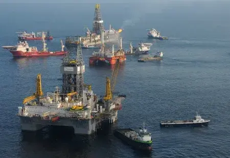
It looked as if the U.S. Coast Guard (USCG) was about to invade Louisiana. Over 6,000 vessels were operating throughout the Gulf of Mexico, nearly as many as the number ships involved in the D-Day landings during the Second World War. This was the magnitude of the BP Deepwater Horizon oil spill disaster, and the national response to mitigate its effects.
Just after 10:00 p.m. CST on April 20, 2010, a massive explosion devastated the BP oil rig Deepwater Horizon, killing 11 crew. The fire aboard the rig—which was located just 50 miles southeast of Venice, Louisiana—continued to burn unchecked for the next day and a half, until the rig finally sank. When it did, it took with it any equipment that could prevent the well it was piped into from releasing its contents into the Gulf. Like a cork removed from a bottle, 60,000 barrels of oil flowed freely out of the well each day for the next 87 days. It would be the largest oil-related natural disaster in U.S. history.
Due to geographical, geological, technological and other factors, the crisis was a prolonged one. As days turned to weeks and months, the nature of the response evolved with them. But decisions made early on were critical to ensuring it ultimately resulted in the successful rehabilitation of the Gulf Coast region.
Here’s how those early days unfolded:
DAY 2 – April 21, 2010: The Deepwater Horizon is still burning and has begun to sink, but already oil sheen is visible on the surface. The Department of Homeland Security (DHS), USCG, National Oceanic and Atmospheric Administration (NOAA), Department of the Interior (DOI) and Environmental Protection Agency (EPA), along with state and local partners, activate the Regional Response Team (RRT). The Team begins drafting plans, providing technical assistance, and deploying equipment to assist BP in their response.
DAY 3 – April 22, 2010: At 10:22 a.m. CST, the Deepwater Horizon finally sinks beneath the waves. In that single instant, it releases its 700,000 gallons of diesel fuel aboard into the Gulf. The riser pipe attached from the rig to the blow-out preventer breaks as the rig sinks—there’s now nothing to stop oil in the well from gushing out into the gulf. In response, Coast Guard activates the National Contingency Plan.
DAY 4 – April 23, 2010: The National Contingency Plan was a product of the lessons learned from the Exxon Valdez spill in 1989. It establishes the Coast Guard as the lead federal on-scene coordinator (FOSC) for any hazardous pollution incident in coastal zones. On this day, the Commandant of the U.S. Coast Guard named Eighth District Commander, Rear Admiral Mary Landry as the FOSC to direct all response efforts to contain and clean up oil from the Deepwater Horizon. The FOSC oversees the Gulf Coast Incident Management Team, headquartered in New Orleans but with offices in each affected state—Louisiana, Alabama, Mississippi, and Florida.
DAY 10 – April 29, 2010: The incredible volume of crude oil coming out the well and NOAA’s trajectories of where that oil is headed prompts the Secretary of Homeland Security to declare the incident to be a Spill of National Significance (SONS). This is the first time in U.S. history that a spill of any kind has been declared a SONS. This designation creates the appointment Coast Guard Commandant Thad Allen to be the National Incident Commander (NIC), acting as the DHS Secretary’s point-person to coordinate response efforts at all levels of government—local to Federal.
DAY 2 – DAY 16: Response is focused on two zones of operation: At Source and Offshore. Operations at source worked on efforts to plug the well and stop the flow of oil. Offshore operations worked to contain the spread of oil in the Gulf. These efforts included:
- Skimming: using booms and other oil absorbing devises to remove oil from the surface.
- Situ burns: igniting the oil to remove it from the water before it can hit land
- Dispersants: deployed undersea (by Coast Guard cutters) or aerially (by Coast Guard planes), these are chemicals that essentially consume oil.
DAY 17 – May 6, 2010: Oil makes its first landfall on the shores of Louisiana’s Chandeleur Islands. Shoreline Cleanup and Assessment Technique teams are deployed for the first time. These are advance teams whose mission is to survey the extent of environmental damage due to oil, and determine the best mode of cleanup.
DAY 18 – May 7, 2010: Cleanup operations begin, and two new zones are added to the response operations structure: Near Shore and In-Shore. Operations in all four response zones continues through the end of the crisis.
DAY 153 – September 19, 2010: The National Incident Commander confirms that efforts to kill the Deepwater Horizon’s well have been successfully completed. With both the casing and annulus of the well sealed by cement, no new oil will flow out into the Gulf of Mexico. Response efforts transition to focus on cleanup.
The response to the Deepwater Horizon oil spill was unprecedented. The U.S. Coast Guard’s key innovation was to treat the response like a search and rescue mission: The Coast Guard gridded off the Gulf, breaking it up into defined response areas. Its aircraft would fly over their assigned grid section—either over shore or the Gulf—and relay to the Gulf Coast Incident Management Team information about the location and quantity of oil present. Incident Coordinators would then deploy the appropriate assets as the zone and nature of the oil there dictated—cutters, burn teams, boom laying teams, dispersant releasing aircraft, land scrubbers, etc.
The scale of the crisis—as well as that of the ensuing response—was unlike anything ever seen. 9000 vessels and 50,000 personnel were involved over the entire course of the crisis. Millions of feet of boom were laid, and 411 situ burns conducted. It truly was a war to save the Gulf Coast.
DHS Component Involved
Redshirts: Not So Disposable 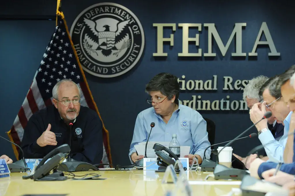
The casual visitor cannot be blamed for confusing the National Response Coordination Center (NRCC) with the U.S.S. Enterprise. In many ways it does indeed resemble the flagship vessel of Star Trek. Start with the attire: each staffer is clad in a colored vest; either red, light blue, dark blue, green, or orange. As in Trek, each color represents both rank and function. There’s also a viewscreen displaying the live common operating picture of an unfolding calamity. Indeed, the NRCC’s whole purpose is to facilitate what you could call “away missions” of specialists deployed to desolate, often dangerous locations to assist the locals.
Like the Enterprise’s bridge, it acts as a central command and control center responsible for coordinating Federal response in support of major disasters and emergencies, particularly catastrophic ones. Its officers, known as National Response Coordination Staff (NRCS), hail from almost every federal agency imaginable. This ensures an efficient whole-of-government approach to managing major disasters.
Maintained by DHS through FEMA, the NRCC is activated in anticipation of, or in response to, an incident of problematic proportions. The most notable time this was done was during 2012’s Hurricane Sandy.
On October 27, 2012, FEMA Administrator Craig Fugate activated the NRCC to Level 1—the highest level of readiness. Level 1 activations are extremely rare, and only occur under certain circumstances:
- When an incident is of such magnitude that the available assets put in place for the response are completely overwhelmed or broken.
- When due to its severity, size, location, impact on public health and infrastructure, the incident requires an extreme amount of Federal assistance.
- When the incident requires extraordinary coordination among Federal, state, tribal and local entities due to monumental damage, severe impact or multi-state scope.
Ominously, Sandy was projected to far exceed all of these criteria. It was the second-largest Atlantic storm ever recorded, affecting the entire East Coast from Florida to Maine, and as far inland as West Virginia, Ohio, and Indiana.
Once the storm hit, it was like nothing before seen. FEMA projected it may need to provide congregate shelter for 1.75 million people, and feed and hydrate another 1.75 million. It would also have to devise a means for treating, stabilizing, and caring for an estimated 265,000 medical casualties. The NRCC set about procuring these necessities and organizing the means to get them into devastated areas.
Here’s How:
When the Region II Response Coordination Center supporting operations in New York and New Jersey—the areas bearing the brunt of the storm’s battering—was overwhelmed on November 2nd, its functions were transitioned to the NRCC.
FEMA then established an Area Coordinator to oversee federal operations in New York and New Jersey. This person had wide authority to manage incident response objectives and allocate resources as the situation necessitated. Anything for which extra support was needed was referred up to the NRCC.
Remember the colored vests? Those wearing Light Blue are the sensors, maintaining continuous situational awareness and scanning for response deficiencies. Those wearing Red, as in Trek, have command of resources and getting them to the away teams. When requests from the field reach the NRCC, they are intercepted by the Light Blue Vests, who then refer them to the proper handler. For military assistance, they go to a Dark Blue Vest; for other resources, they go to the Red Vests.
The Red Vests are sat at computer terminals along rows of long tables resembling the Great Hall of Hogwarts. Each row is dedicated to finding, coordinating, and deploying a different resource type to the location that desperately needs it. There are rows for coordinating volunteers, emergency services, financial resources, external affairs, and all other manner of assistance that may be required.
During Sandy, these vigilant, vested crisis managers worked 14 hour shifts, yet, despite exhaustion, devised remarkably innovative solutions. In one example, they found free temporary shelter for 4,000 displaced individuals in the New York-New Jersey area by partnering with Airbnb.
In all, FEMA executed one of the largest deployments of personnel in its history (over 900 were sent into storm-affected territory), delivered over $1.2 billion in housing assistance to more than 174,000 survivors, and allocated over $800 million for debris removal and infrastructure restoration.
DHS Component Involved:
Like Two Ships Sinking in The Night 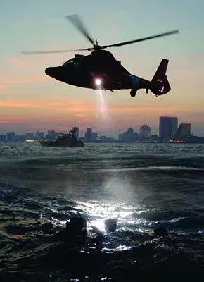
Hurricane Joaquin was the second major cyclone storm of the 2015 season. Forming in the last days of September, it battered the Bahamas, damaging roofs and making roads impassable. It looked poised to do the same to the United States as it worked its way northward, causing six U.S. states in the South East to declare states of emergency in anticipation of heavy torrential rain and extensive flooding like that seen in the Bahamas. Then, the winds changed direction and the storm began blowing out to sea, sparing the East Coast—save for some flooding in South Carolina.
But the story doesn’t end there. Those still out on the high seas—mostly slow moving cargo ships—were now directly in the storm’s path. Just short of Category 5 strength, Joaquin kicked up sea swells of 50-feet and produced winds of 155 mph. It was the strongest Atlantic hurricane since 2010’s Igor.
On October 4, as ships now caught in harm’s way began steaming at full speed to try and outrun the storm, the valiant men and women of the U.S. Coast Guard (USCG) began flying straight into it. Their mission: locate the El Faro, a 735-foot containership with 28 Americans and five Polish crewmen onboard. It was on its way to San Juan, Puerto Rico from Jacksonville, Florida when the storm disabled its propulsion and power systems and it began taking on water, causing it to list 15 degrees. It’s last known position was near the eye of the hurricane.
El Faro made its last contact with the Coast Guard at 7:30 a.m. Thursday—three days prior on October 1. It hadn’t been heard from since. Winds in excess of 120 mph and low cloud cover made it virtually impossible for Coast Guard aircraft to inspect the surface of the water. By Sunday, October 4, conditions—though still dangerous—had improved enough to allow an intensive search. A Coast Guard C-130 Hercules airplane and two Air Force Hurricane Hunter planes were dispatched. On the first day alone, Coast Guard personnel searched more than 70,000 square nautical miles for the El Faro. What they found instead was one of its containers floating in the water; then some life vests, rings and oil sheen.
It seemed the El Faro had sunk not far from it’s last known position. With the storm still raging, the Coast Guard vowed to push its operational limits as far as possible to maintain its search for any survivors.
"We are not going to discount somebody's will to survive, and that is why we are still searching today," said Coast Guard Captain Mark Fedor, resolving to continue the search.
Meanwhile, a rescue operation of another crew put in jeopardy by Joaquin was well underway.
On October 1, the Coast Guard 7th District Command Center watchstanders received a message from the British Coast Guard in the Bahamas that they had a received an emergency Inmarsat satellite message stating the Bolivian-flagged cargo ship Minouche was listing 30 degrees to port and all 12 crew members aboard were making preparations to abandon ship.
The vessel began sinking about 51 miles north of Haiti. Amid fierce winds and violent swells, the crew—seeing no other choice—abandoned ship for a small life raft.
USCG diverted the Coast Guard Cutter Northland and launched an MH60 Jayhawk helicopter from Great Inagua, Bahamas to the last known position of the Minouche. In addition, a good Samaritan vessel and member in the Automated Mutual Assistance Vessel Rescue System (AMVER) received word of the Minouche through AMVER and diverted to render assistance.
At 10:30 p.m., the AMVER-participating ship arrived. Though the 212-foot cargo ship Minouche had sunk—along with more than $2 million worth of cargo—the good Samaritan ship was able to locate the raft containing the crew. The Coast Guard Jayhawk helicopter arrived soon there after; and by 11:00 p.m., all 12 crew had been safely hoisted out of the water and flown back to Great Inagua.
Search and rescue operations is one of the U.S. Coast Guard's oldest missions. For more than 220 years, and for as long as there are those in peril on the sea, USCG stands ready to render assistance—no matter the conditions.
DHS Component Involved
Barks Mark the Spot 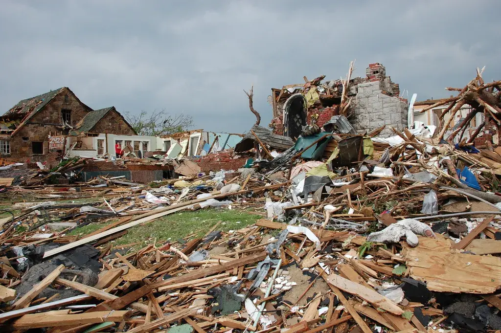
“It was as if a nuclear bomb had gone off.” That is how many described the devastation left behind by the tornado that laid waste to the town of Joplin, Missouri, on May 22, 2011. At just after 5:30 p.m. that Sunday night, the tornado—an F-5, indicating the strongest force possible—hit the unsuspecting quiet Midwestern city. It cut through the town, leveling everything in its path: homes, schools, hospitals, even a Wal-Mart Supercenter. Joplin’s tornado would become the deadliest to hit the United States in over 60 years.
This tornado was unique. Unlike others that tend to cast a wide net of minor damage; the Joplin tornado produced a very concentrated path of near complete and total destruction. Within the 15-mile-long, 2-mile-wide affected area, there was little left un-flattened. Bits of the wooden framing that once supported the city’s buildings became strewn about the city’s streets. In their destruction they had become dunes, barricades cutting off the city from the outside world—and the help it could provide. The leveled landscape seemed almost entirely devoid of life, save for the city’s power and communication lines now snaking about the ground like feral filament-based electric eels. The destruction was so remarkably even, it’s easy to understand the comparisons to images of Hiroshima in 1945.
At 8:00 p.m., as information was just starting to get out and the scale of the disaster known, Missouri Governor Jay Nixon declared a State of Emergency. He ordered MOTF-1 to Joplin to begin search and rescue operations.
MOTF-1—or, Missouri Urban Search and Rescue Task Force 1—is one of 28 specially trained Urban Search and Rescue (US&R) teams distributed across the country that are funded and trained by the U.S. Department of Homeland Security through FEMA.
As fate would have it, earlier that very day MOTF-1 was concluding a four-day response and deployment exercise as part of a DHS/FEMA National Level Exercise in St. Louis. The exercise simulated a response and recovery environment consistent with a devastating earthquake—layers of debris to sift through, and so forth—and therefore, serendipitously applicable to the type of destruction found in the wake of tornadoes.
MOTF-1, based in Columbia, Missouri, is strategically placed in the middle of Missouri to ensure rapid deployment to any part of the State. Once FEMA activated the team, it had 4 hours to mobilize and embark for the crisis area—there can be no time wasted when lives are at stake. Fresh off the simulation exercise, MOTF-1 was uniquely prepared for what it would find when it at last arrived in devastated Joplin later that night.
The team arrived late the night of the tornado, May 22, and immediately set about their work, working into the early hours of Monday, May 23. By then, nearly 1,500 were known missing, and the time to save them disappearing. To make matters worse, the specter of more tornadoes possibly touching down in the area was an ever present threat.
MOTF-1 focused its efforts on searching the collapsed structures along what was left of 20th Street. One of the main thoroughfares of Joplin, it was also the area hardest hit by the tornado.
The area served as the town’s commercial district. Warehouse stores Wal-Mart and The Home Depot were located there. These types of stores were built using “tilt up” construction, whereby walls are made of reinforced structural concrete that is poured flat and then, once dry, tilted up into their final standing position. These walls are kept standing by the structure’s roof, which acts in much the same way as a keystone in a Roman arch—a block that keeps everything from falling in on itself. When the tornado hit, it quickly compromised the roofs of these stores, causing the total collapse of the rest of the building soon thereafter.
To get to those trapped beneath the 80,000+ lbs. walls, MOTF-1 began operations to break through, remove, and stabilize them. FEMA’s Canine Search and Rescue teams became a critical asset in these efforts.
Known as Canine Search Specialists, these dogs are critically important during structural collapse incidents. Because of their incredible sense of smell, they can detect a person’s scent—even if that person is buried deep under layers of rubble. Because of their small size, these animals can access areas that are either inaccessible or unsafe for their human teammates.
Here’s how canine search and rescue operations in Joplin, Missouri worked:
- The human members of the Canine Search and Rescue Team first assessed the safety of their sites and devised a search strategy.
- Then, the dogs were let off the leash to begin the search.
- The dogs continuously let out periodic barks to act as a homing beacon if they go out of visual range of their human handlers.
- When the dogs detected trapped survivors, they barked three times in rapid succession to alert their handlers of this fact.
- Then, handlers met and marked their Canine Search Specialists’ locations with a flag.
- All of these flagged sites were then mapped for the rest of the MOTF-1 crew to deploy heavy duty equipment to rescue those trapped underneath.
Many trapped in Joplin’s rubble were saved in those early hours because of the work of FEMA’s Canine Search & Rescue Teams. These remarkable creatures are also remarkably humble; for helping survivors get their life back, all they ask for in return is a nice chew toy.
DHS Component Involved
Fixin’ to Fix 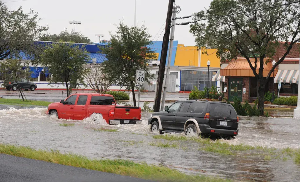
From Babylonian flood myths to blockbuster films with ever-ballooning CGI budgets, floods have been a reliable trope in historical works of fiction and modern Hollywood dramas alike. Flooding itself is actually more common than the works of fiction it inspires would suggest.
In the United States, flooding is the most common type of natural disaster to hit the country. In fact, the federal government spends more mitigating flood damage than any other type of hazard. FEMA estimates that $260 billion of costs related to flooding have been borne by the United States between 1980 and 2013. Furthermore, floods are just as deadly as they are costly. A fully grown adult can be swept away in less than 6 inches of moving water. When moving water depths reach 2 ft., cars began to get swept away.
Floods are particularly deadly because many of us underestimate the threat. All of us use water every day, and we forget that it doesn’t take a barrage of water to transform the normally benign substance into a killer. Even in the strongest of downpours, water may accumulate only gradually. This may coax people into a false sense of security; not heeding calls to evacuate until it’s too late, they’re trapped, and no one can come for them. Flood waters can also short electrical systems, causing electrocutions and fires. For these reasons, floods are the #1 cause of weather-related deaths in the U.S.
For those who survive, the costs of getting life back to business as usual can be daunting. As anyone who’s ever had to pay to fix a burst pipe in their home knows, the cost to repair water damage quickly runs into the thousands of dollars. Now imagine if the entire first floor of your home was under a foot of water for weeks on end; the costs would be astronomical.
This is precisely what happened during the severe storms that effectively drowned Houston, Texas in May 2015. Heavy rain began pummeling the city of over 2 million on May 4. It didn’t stop for the rest of the month. It didn’t take long before Texas’s largest city bore a greater resemblance to Venice’s lagoon. By May 26, Texas Governor Abbott declared 37 Texas counties disaster areas, 3 people were confirmed dead, and 30 others missing.
President Obama signed a Disaster Declaration for Texas on May 30th. The declaration authorized the Department of Homeland Security’s Federal Emergency Management Agency (FEMA) to make available federal disaster aid and support state, tribal, and local authorities in the recovery effort.
Here is how FEMA brought relief to Houstonians:
- Kevin L. Hannes was named the Federal Coordinating Officer. In this role he was responsible for implementing federal recovery operations in the affected areas.
- FEMA personnel arrived on the ground to supplement their Texas emergency management counterparts in inspecting and assessing damage to structures.
- Within a few days, two 32-foot long FEMA RVs arrived in Harris Country. These were specially designed Mobile Recovery Intake Centers, offices where flood victims could meet face-to-face with FEMA specialists and register for disaster assistance funds. The centers were staffed with 12 FEMA specialists each, and set up shop in the Meyerland and Spring Branch neighborhoods—the two worst affected by flood waters.
- FEMA personnel conducted door-to-door canvassing in flood affected areas to inform residents about the disaster assistance program and address other needs.
- A permanent Disaster Recovery Center opened in Houston on June 18. The center served as a one-stop shop for eligible survivors seeking help from federal and state sources as quickly as possible.
As with any calamity, rumors can spread as quickly as flood waters. In Houston’s case, one particularly persistent rumor was that flood victims who had home flood insurance were ineligible to register for FEMA’s disaster assistance program. Not only was this untrue, the confusion it caused could’ve hampered the efforts to efficiently process disaster assistance claims. In response, FEMA set up a website on this and all rumors surrounding the Houston flood response to quell the volume of misinformation floating about.
Thanks to FEMA’s rapid deployment and efficient, personalized service, many flood victims in Houston got a Hollywood ending.
DHS Component Involved
The Lost Become Found with FINDER
Four men, trapped under 10 feet of bricks, mud, and other debris; oxygen being used up with every breath. Time is of the essence when searching for these men, as every breath and minute passed is another breath and minute closer to death.
It was four minutes until noon on April 25th, 2015 when the ground started to shake and buildings began to collapse. One of the worst earthquakes in recent history struck Western Nepal that day, killing nearly 9,000 people and injuring almost 22, 000. The violent quake shook not only the ground, but the Nepali economy. The disaster caused $10 billion in damage, the equivalent of nearly 50% of the country’s GDP.
The best test of any new technology is how well it performs in a real-world operation. The earthquake provided a newly invented device, aptly named FINDER, its truest test yet. Finding Individuals for Disaster and Emergency Response, much better sounding as FINDER, was developed by the Department of Homeland Security’s Science and Technology Directorate (S&T) and the National Aeronautics and Space Administration's (NASA) Jet Propulsion Laboratory (JPL) to better assist with recovery efforts during natural disasters.
Two prototype FINDER devices were deployed to support search and rescue teams in the Nepali areas most devastated by the earthquake. The devices arrived on April 29th, days after what rescuers consider the “Golden Hour”, the hour directly after a disaster in which found survivors have the best chance survival. There was little hope of discovering the trapped men.
That all changed with FINDER on the scene. The FINDER operators activated the microwave detection functions and, after scanning various collapsed structures and piles of rubble, were able to detect two different sets of heartbeats beneath two different collapsed structures. The microwave detection of the heartbeats allowed the rescue workers to find the men, and after days lying trapped under rubble, they were pulled from the dust, debris, and destruction. Without FINDER, these men would have perished like so many others did in the aftermath of the earthquake.
FINDER uses microwave-radar technology to detect heartbeats of victims trapped in wreckage. The carryon-sized device has previously demonstrated capabilities of detecting people buried under 30 feet of rubble, hidden behind 20 feet of solid concrete, and from a distance of 100 feet in open spaces. One of the advantages of FINDER is that microwaves do not bounce back off of debris and cause interference; a person just needs to have a pulse in order to be found. This allows search and rescue teams to find those that may have been knocked unconscious during the disaster.
The work of those in the DHS S & T directorate contributed directly to the saving of those four lives in Nepal. With FINDER field tested and successful, it will not be surprising to find FINDER technology coming to a first responder station near you. FINDER is the next phase of disaster recovery and will be critical to saving lives in the next disaster.