

The Science and Technology Directorate (S&T) has partnered with Deltares USA to conduct demonstrations, trainings, and performance testing for the new accessible compound flood and impact assessment tool, which will help at-risk communities better prepare for and respond to severe weather events.
Our coastal communities have taken a real hit in recent years. With extreme weather events on the rise, learning from past incidents and emerging trends is the key to protecting lives and property. Having the right compound flood modeling systems and data in place to study, simulate, and predict threats makes collaboration and critical decision-making that much easier, so when the time comes, response can be swift.
S&T has been working with Deltares USA and the city of Charleston, South Carolina, for two years to develop and pilot a state-of-the-art suite of community-oriented flood-hazard modeling and impact assessment technologies and software that will soon be available to inform field operations and emergency response before and after any events make landfall. The tools, now collectively known as FloodAdapt, will provide responders, emergency managers, and policy makers in flood-prone communities with capabilities to establish stronger planning and preparation strategies.
“Our efforts in Charleston have played a critical role in the ongoing development of FloodAdapt,” said S&T Program Manager Ron Langhelm. “Thanks to engagement with local emergency managers, first responders, and community decision makers, along with continual performance and user testing, we’ve been able drastically improve upon FloodAdapt’s tools, and enhance their capabilities and scope of use.”
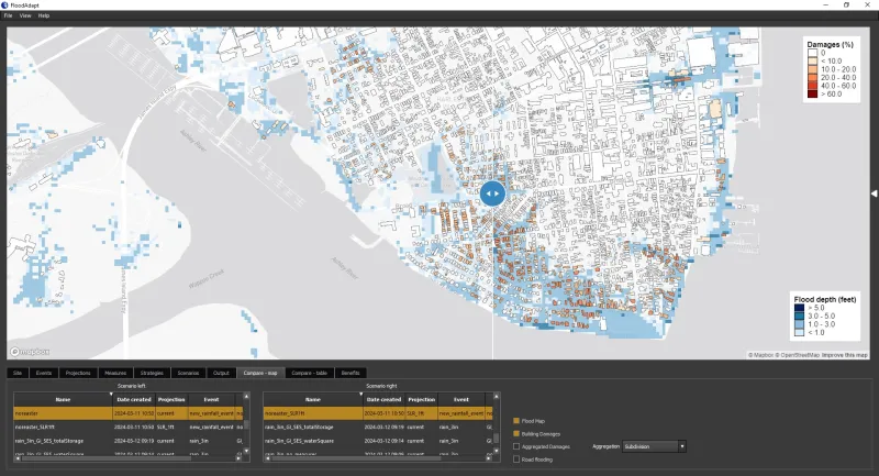
FloodAdapt has unique, user-friendly components that help users create community-specific flood simulations, study related impacts, and investigate the efficacy of potential preventive and mitigative efforts and responses.
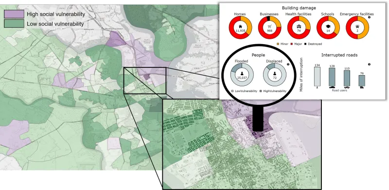
SFINCS is an open-source modeling tool that rapidly and dynamically simulates compound flooding events that impact large-scale coastal environments, and calculates interactions between related phenomena such as rainfall, storm surges, and river discharge. Delft-FIAT is an open-source flood impact assessment modeling tool that evaluates flood damage to buildings, utilities, and roads.
FloodAdapt incorporates innovative decision-support features, helping bring them into practice. These include an equity-weighting tool that (optionally) incorporates income data in determining equity-weighted damages and risk, infographics that use social vulnerability data to evaluate the equitable distribution of impacts and benefits, and a benefits calculator to assess the risk-reduction benefits of measures or strategies that will help lessen the impact of future flood events.
“With these advanced capabilities, FloodAdapt is able to provide some of the most accurate flood-related models, infographics, and infometrics that are currently available,” explained Langhelm. “Users can integrate FloodAdapt into their own toolsets and plug in publicly available data or use their own. They can then study past weather events, simulate hypothetical scenarios, and evaluate vulnerabilities, risks, and mitigation strategies that are the most relevant to their needs or interests.”
While it is currently being piloted for coastal flooding research in Charleston, Langhelm and the Deltares team are working hard to raise awareness about and further improve FloodAdapt before it transitions to the field.
“Continuing to spread awareness about, improve, and develop new innovations for FloodAdapt are major priorities for us,” said Langhelm. “We want to make sure that it will always be accessible and useful to anyone who may want to use it—whether they are government organizations, academia, emergency managers and responders, or just everyday citizens who have their own interest in learning about flood modeling and research.”
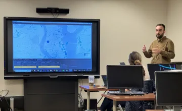
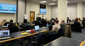
To meet these goals, in March 2024 the Deltares team conducted demonstrations, trainings, and performance testing with members of the flood research and response communities in Charleston and Baltimore. Both trips were a great success.
“FloodAdapt made quite an impression in Charleston and Baltimore,” said Langhelm. “Our emergency managers in South Carolina were impressed with the improvements we’ve made and the capabilities we’ve added and are looking forward to using them with their current models and datasets as a part of their future flood research and planning efforts.”
“Our colleagues in Maryland weren’t as familiar with FloodAdapt,” continued Langhelm. “However, they found it to be a powerful, user-friendly tool, and believe that it can play a key role in their current flood research and mitigation efforts. We are preparing additional training materials for them so that they can continue to get more comfortable with FloodAdapt and eventually teach their regional partners how to use it as well.”
The team has also been consulting with academia to make FloodAdapt even more effective in the field.
“We’re working with the George Washington University to study income, population, and other related factors, and looking at how these social indicators should be better accounted for when implementing flood-related policies,” explained Langhelm. “And our colleagues at Dartmouth College’s School of Engineering have created an uncertainty framework for damage modeling, that, if incorporated into FloodAdapt, will help users more accurately predict the probability of a flood occurring in any given area.”
A growing number of international partners in the European Union, including the European Centre for Medium-range Weather Forecasts and emergency responders in Ireland and Denmark, are also interested in exploring ways to implement FloodAdapt into their regional and local coastal communities.
“All of these partnerships are critical,” said Langhelm. “Ultimately, we all have the same shared goal: to raise awareness about FloodAdapt and teach interested users how to effectively use it to enhance their communities’ resilience to flood events.”
In the coming year, the team will implement two new FloodAdapt capabilities to address technical gaps identified during recent user engagements: the ability to evaluate accessibility impacts (like access to a hospital) when roads are flooded and the ability to evaluate the damage-reduction effectiveness of coastal nature-based solutions (like coral reefs and coastal wetlands that serve as buffers from waves and high-tides).
Findings from the Charleston pilot will be documented in a peer-reviewed paper. The team is also creating and disseminating a series of FloodAdapt tutorial videos and technical manuals.
“The paper will serve as another means of spreading the word about FloodAdapt and its utility, while the videos and manuals will be valuable resources to anyone who is interested in accessing and using FloodAdapt,” explained Langhelm.
Each video will provide a brief overview of a specific functionality and demonstrate how it can be used, while the online technical manuals, which can be accessed directly from within FloodAdapt, will offer complementary written instruction.
S&T and Deltares plan to make FloodAdapt available to the public this October and will continue to expand upon, enhance, and promote it based on continual feedback from stakeholders in the flood research community.
For related media requests, please contact STmedia@hq.dhs.gov. Visit S&T’s Community and Infrastructure Resilience page to learn more about our ongoing flood-related research and development efforts.