Have you ever wondered what happens when a dam fails? How fast and how far would all the water, which was being held back, reach? How long would it take to stop and just how deep would the flooding be? And, most importantly, how much damage would it cause to properties, infrastructures and the environment downstream from the dam? Not to mention the toll on human life.
 With more than 96,000 dams across the United States, those are the kind of questions dam safety engineers in state and government agencies and emergency managers must answer in order to prevent loss of life and to protect properties and critical infrastructures in case of a dam failure. Almost 10 years ago, the Department of Homeland Security (DHS) Science and Technology Directorate (S&T) waded into the discussion; developing a modeling and simulation tool to help provide better answers to those questions. To date, that tool – the Simulation-Based Decision Support System for Water Infrastructural Safety or - DSS-WISETM has modeled more than 1,800 dams so far, saving the American taxpayer nearly $50,000,000.
DSS-WISETM was developed to support the DHS Office of Infrastructure Protection, Dams Sector Section and the Federal Emergency Management Agency (FEMA). S&T funded the free flood simulation software, which quickly calculates the spread of flood water in case of dam or levee breaches.
S&T has recently released a newer version called DSS-WISETM Lite that allows for more complicated simulations. S&T funded the National Center for Computational Hydroscience and Engineering (NCCHE) at the University of Mississippi to develop the DSS-WISE™, which combined a state-of-the-art numerical model for two-dimensional flood simulation with decision support tools to map the flood and evaluate its consequences.
In 2011, NCCHE began to develop DSS-WISE™ Lite – a web-based version of this software with automated input data preparation. This web-based, automated dam-break flood modeling and mapping capability became available in 2012. In 2015, DHS Office of Infrastructure Protection, Dams Sector Section, and the Federal Emergency Management Agency (FEMA) decided to support NCCHE to create a standalone, improved version of DSS-WISE™ Lite.
“This is a dam-break flood modeling project S&T funded with a total investment of $1.6 million and a return on investment (so far) of $50 million, as well as countless lives and personal property saved,” said Mike Matthews, program manager for the S&T Research Development Partnerships’ Office of National Laboratories. “This number means that states, counties and local municipalities did not have to pay for this tool or service.”
While dam failure is normally a rare event, the extreme rainfall and exceptional floods driven by hurricanes led to a large number of dam failures over the last two years. In 2015, Hurricane Joaquin caused the failure of 51 regulated dams in South Carolina. In 2016, Hurricane Matthew caused 25 dam failures in South Carolina and 17 dam failures in North Carolina.
Around 16,000 dams in the U.S. are classified as high hazard dams whose failure could result in loss of life, significant property damage, lifeline disruption and environmental damage. These dams are required to have Emergency Action Plans, which is a formal document that identifies potential emergency conditions at a dam and specifies preplanned actions to be followed to minimize loss of life and property damage. An engineering study of a dam takes days to complete and could cost $32,500. DSS-WISE™ takes minutes and is free.
“In order to have an emergency action plan for a dam, you have to be able to model it,” explained Matthews. “You have to be able to know if there is a breach in a dam, what happens downstream, what communities, businesses and infrastructures are impacted.”

This is where the DSS-WISE™ Lite software comes into play. “The users can set up and launch a two-dimensional dam-break simulation in about five minutes,” said Dr. Mustafa Altinakar, director and research professor at NCCHE. “The input data for the model is prepared automatically, and in 73 percent of the cases, the simulation results’ GIS-compatible format are returned to the user within half an hour. It is the fastest model available,” he added.
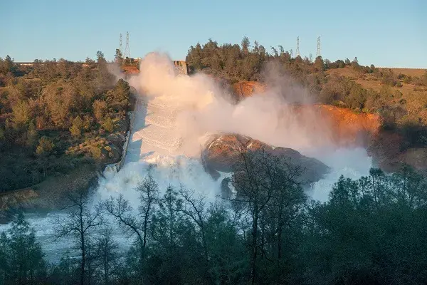
The exceptional computational speed of DSS-WISE™ Lite makes it an ideal tool for operational modeling during dam safety emergencies. Dam safety engineers and emergency managers from state dam safety offices, FEMA and other agencies have used DSS-WISE™ Lite during numerous emergencies to run operational simulations that were used to prepare emergency response plans in a very short time. While it was still being beta tested in October 2016, the system was used for emergency dam-break simulations in South Carolina. More recently, in February 2017, dam safety engineers in California performed 60 simulations to test different spillway release scenarios during the Oroville Dam incident.
Already, 35 states and various federal agencies are using the DSS-WISE™ Lite capability free of charge. Since its release in November 8, 2016 through the end of November, 2017, the system handled 3,115 dam-break flood simulations for 876 dams. On average, around 22 simulations are added daily.
User groups have been set up for FEMA headquarters, 10 FEMA regions and the states under their coverage, national Weather service and Argonne National Laboratory. Each group is assigned their geographic area for their simulations. The groups are self-managed by a group manager. Local dams safety or emergency officers who want to use the system must register online apply to their corresponding geographical group.
A few weeks ago, Altinakar’s team took down the DSS-WISE™ Lite system for five days to implement major upgrades and improvements. “I was flooded with messages asking ‘When is this going to be back again because our program heavily relies of DSS-WISE Lite!’ People were impatient to use the capability,” said Altinakar.
“The big success story here is the number of years DSS-WISE™ has been going on, and it is not just the money that have been saved, but it is also the lives that have been potentially saved and the improved planning for emergency managers in these communities,” said Matthews. “The good part for me as a program manager is to know that technology we developed 10 years ago continues to be used and is paying large dividends, which means that the project was sorely needed.”
For access to the system, please apply online.
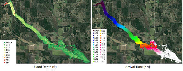
Photo Captions:1. By California Department of Water Resources; Water flowing from the eroded overflow spillway of Oroville Dam, CA. February 11, 2017.2. By Dr. Mustafa Altinakar from the National Center for Computational Hydroscience and Engineering at the University of Mississippi; Dam-break flood maps for Mantee Lake Dam in Mississippi computed using DSS-WISE™ Lite.
