The Fukushima Daiichi nuclear power plant accident on March 11, 2011 resulted in public misconception that radioactive fallout would impact the west coast of the United States. State and local emergency managers did not have an effective way to communicate or project the effects, which led to disparate reporting and conflicting messages conveyed by the media.
 The Federal Emergency Management Agency (FEMA) identified the need for a systematic platform where technically accurate and decision-making information could be easily shared across state, municipal and tribal jurisdictions. They contacted the Department of Homeland Security (DHS) Science and Technology Directorate (S&T) – DHS’s research and development arm – for assistance.
That partnership has grown beneficially for both organizations and generated numerous success stories. Since 2015, S&T’s National Urban Security Technology Laboratory (NUSTL), a testing and evaluation laboratory with a first responder focus located in New York City, has worked with RadResponder, a multi-function online network for emergency managers, first responders and radiation subject matter experts.
RadResponder is identified in the 2016 Nuclear Radiological Incident Annex as the national system for radiation data aggregation and is considered the standard resource for giving emergency managers a common operating picture, whether planning for the future or monitoring radiation in real time. Groups and individuals involved in radiation response can request to create an online account and become part of this network, which currently includes thousands of organizations and individual first responders.
“RadResponder builds capabilities for state and local response and connects them with federal assets from FEMA, the Environmental Protection Agency (EPA) and the Department of Energy (DOE),” said Ben Stevenson, an S&T Program Manager located at NUSTL.
While FEMA owns RadResponder, S&T, EPA and DOE have supported the development of some tools within the network. In January 2018, FEMA adopted the Radiation Decontamination tool (Rad Decon), developed by S&T and the EPA, into the system. Its developers refer to it as a “discussion support” tool meant to provide executive decision makers and subject matter experts a common information source to draw from in disaster preparation.
Even more recently, RadResponder added the Radiological Operations Support Specialist (ROSS) toolkit, an S&T-funded HTML tool that organizes important reference material for radiation specialists, to support subject matter experts in their analyses.
“RadResponder is constantly evolving,” said James Blais, FEMA’s RadResponder Program Manager, “S&T has been very active lately, helping with ROSS and Rad Decon, to spot needs and provide insight and perspective slightly different than what we had.”
A thriving network
RadResponder consolidates information from all levels of government to benefit operations. In the past, local emergency response plans have been made independent of other agencies and governmental elements, with varying methods and effectiveness. Now, with radiation data federated on RadResponder, state and local governments are given a uniform, constantly updated set of tools to build their approach. The common platform allows several entities to communicate with each other where they might not otherwise.
“Some people use it to build relationships with other organizations,” said Blais. “It’s like [a social network] for the radiation community.”
RadResponder is gradually becoming a more holistic radiological emergency network. It continues to grow rapidly as more response agencies join and new tools are added. Organizations have been eager to join—Michigan has adopted RadResponder state-wide, and Iowa and Kansas use it to track background radiation. These organizations benefit from the different tools in the network, which are updated constantly.
“We want to help communities at large become more resilient instead of reinventing the wheel at every turn,” said Blais.
A “discussion support” tool
 Whether a catastrophe is natural or man-made, emergency managers need to respond quickly with the optimal solution. Making decisions on the fly can be difficult, which is why significant planning must go into a disaster response strategy. Many conversations need to happen, and they need to cover a range of possible scenarios. The Rad Decon tool was developed to facilitate those very discussions.
While some executive decisions can be supported by a straightforward decision tree, there are other problems—in this case, large scale radiological incidents—for which the solution depends on more nuanced factors. This is where the “discussion support” (as opposed to “decision support”) distinction comes into play. Radiological emergencies could require a different response depending on the type of radiation, the landscape or the time of year. The Rad Decon tool guides users through a continuum of parameters and priorities they can set based on the conditions of a specific radiological event to prioritize decontamination strategies. The tool uses this data to provide a list of possible solutions that gives a common point of reference to guide the emergency management conversation. The application even allows for printable results to aid the discussion.
“The Rad Decon tool is designed to take you from all your options to a couple key options,” said Stevenson, “We want responders to have the ability to collect data and make decisions quickly and more efficiently.”
The tool was inspired in 2013 by a decision making model used in the United Kingdom. S&T and the EPA worked together to establish the needs the tool should fulfill, and they were then able to put together the pieces to fully transition it to the FEMA-hosted network.
The ROSS toolkit was implemented in May 2018, providing an infrastructure to better integrate subject matter experts from the ROSS program, a position in the emergency management structure that can provide radiological expertise to incident commanders and emergency managers. The toolkit provides a ROSS with a streamlined analysis capability, aiming to further improve the quality of information provided to first responders around the country—in this sense, the entirety of RadResponder serves as “discussion support,” promoting dialogue between organizations, leveraging the strengths of their experts and executives.
More than a toolbox
 The RadResponder network provides a host of other tools for emergency managers to keep informed. There are videos, repositories of past drills and exercises, training information, factsheets, manuals and more.
Exercises are catalogued in several different ways, using dashboards with charts, graphs and even interactive maps to provide insight for the future. Users can search for past events and view this information in any one of these interactive forms. They can also filter activity down to their own organization to stay updated on their own events, equipment, facilities and personnel.
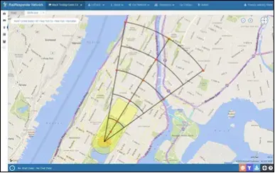
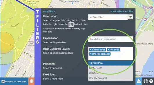
Radiological response teams around the country have joined RadResponder, able to connect their radiological detection hardware—computers, meters, samplers, etc.—to the network to perform experiments and store data in real time. The network can connect to detectors through Bluetooth equipment, a mobile app or, simply, a radio. State and local governments have used the network to test, plan and train their radiological response teams. RadResponder is also integrated into the Radiological Dispersal Device (RDD) Guidance, providing a science-based tool for responding in the First 100 minutes of an RDD detonation, recently released by DHS S&T, FEMA and DOE NNSA.
Another recent addition to the network was the ability to merge data from different events together—an example of how RadResponder helps give experts a unified picture of radiological response across agencies. The network also recently made the mobile app accessible to a wider range of smartphones, which will allow more robust communication, more data shared between and within organizations in their planning and research.
National impact
The teams behind RadResponder want to consolidate information as much as possible to allow emergency managers easy access to a shared radiation emergency response resource. Future capabilities will include a two-way chat function (accessible through the RadResponder site and the mobile app), an alert system for teams to immediately have awareness when radiation has reached a certain threshold, and the ability to receive data from drones connected to the network.
More operational tools will promote a faster, more informed radiological response nationwide, as Ben Stevenson said: “A radiological emergency is an event of national significance.” Certainly, local preparedness is an excellent first step to reducing the long term impact of an incident by preparing responders to manage information and make data driven protective action decisions.
Captions:
1. ROSS logo2. A RadResponder screen shows the 10-point monitoring survey points overlaying a map image of a radiological incident. This feature is one example of the guidance tools jointly developed by NUSTL and selected for integration in FEMA’s RadResponder system.
3. A 10-Point Monitoring Plan layer can be added into RadResponder, allowing first responders to visualize the suggested points for monitoring on a map.
