U.S. flag

An official website of the United States government

Government Website

Official websites use .gov
A .gov website belongs to an official government organization in the United States.

Safely connect using HTTPS

Secure .gov websites use HTTPS
A lock () or https:// means you’ve safely connected to the .gov website. Share sensitive information only on official, secure websites.

Breadcrumb

  1. Science and Technology Directorate
  2. News Room
  3. Feature Article: How S&T Supports the Next-Generation Emergency Operations Center

Feature Article: Operationalizing Community Lifelines—How S&T Supports the Next-Generation Emergency Operations Center

Release Date: September 12, 2024

When disaster strikes, emergency managers nationwide provide timely and accurate status updates to enable swift decision making and prioritize allocation of limited resources. Armed with the Science and Technology Directorate’s (S&T) Community Lifeline Status System (CLSS) tool, incident leaders can now quickly assess lifelines, easily communicate with teams, and maintain data-informed situational awareness through every stage of planning, response, and recovery.

Image
On the far left, a lifeline is defined as “A lifeline enables the continuous operation of critical business and government functions and is essential to human health and safety for economic security”. Purpose: Root Cause Analysis, Interdependence, Prioritizations, and Ease of Communication. The flow of logic for the FEMA Community Lifeline construct is displayed in four rectangles with arrows connecting related elements: Status  What (with light a blue background), Impact  So what? (with a red background), Status  Now what? (with a green background), and Status  What’s the gap (with a gray background). Community Impact is defined as “Occurs when basic lifelines or capabilities are disrupted and reduce their ability to provide critical services to survivors”. The FEMA Community Lifeline construct diagram defines each of the following lifelines using related imagery. Each of the lifelines has additional imagery reflecting essential components of each category. For the Safety and Security lifeline, related imagery includes Law Enforcement/Security, Fire Services, Search and Rescue, Government Services, and Community Safety. For the Food, Hydration, Shelter lifeline, related imagery includes Food, Hydration, Shelter, and Agriculture. For the Health and Medical lifeline, related imagery includes Medical Care, Patient Movement, Public Health, Fatality Management, and Medical Supply Chain. For the Energy lifeline, related imagery includes Power and Fuel. For the Communications lifeline, related imagery includes Infrastructure, Alerts, Warnings, and Messages; 911 and Dispatch, Responder Communications, and Financial Services. For the Transportation lifeline, related imagery includes Highway/ Roadway, Mass Transit, Railway, Aviation, and Maritime. For the Hazardous Materials lifeline, related imagery includes Facilities and HAZMAT, Pollutants, and Containments. For the Water Systems lifeline, related imagery includes Drinking Water Infrastructure and Wastewater Management.
FEMA’s Community Lifelines Construct. Photo credit: FEMA.

The unprecedented increase of severe weather, manmade risks, and complex threats to our communities presents significant challenges to our nation’s emergency managers. As the number of incidents continues to rise, so does the sheer amount of data agencies have at their disposal. Emergency managers need this critical information to ensure key resources, including staff, remain available to deploy at a moment’s notice. But it is also important that agencies have tools in place to aggregate, analyze, and operationalize the data.

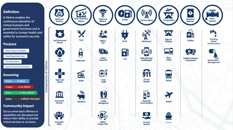
FEMA created its Community Lifelines construct to reframe this incident information, understand and communicate incident impacts using plain language, and promote unity of effort to prioritize efforts to stabilize the lifelines during incident response. Now, S&T is working with FEMA and other partners on a platform that will integrate various response systems and standardize incident management and reporting.

S&T partnered with G&H International Services, Inc. (G&H) to develop the Community Lifeline Status System (CLSS) to operationalize FEMA’s Lifelines utilizing data-driven analytics to inform lifeline reporting nationwide by 2025. The construct defines how jurisdictions assess and prioritize the impacts of a community's essential services and infrastructure during a disaster response, ensuring that communities can recover and maintain critical functions like safety, health, and communications.

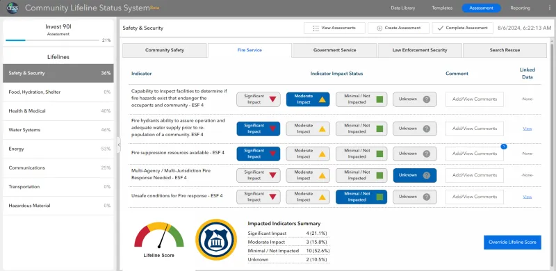
Built with the rapid pace of an emergency operations center in mind, the CLSS is designed and equipped with features for ease of use and customization to meet the unique needs of emergency managers. This includes planning the development of community-specific lifeline indicators that can be exported and shared in PDF reports, to include comments for additional context and justification to external stakeholders. The tool leverages Esri ArcGIS frameworks, allowing jurisdictions to build on existing technology investments and data. Completed Lifeline impact assessments can be instantly shared with cooperating organizations across jurisdictions.

Image
Community Lifeline Status System (CLSS) screen capture displays the Assessment page within the tool. On the top left-hand corner, the title shows Invest 90I Assessment with 21% lifelines outlined in blue. Beneath it is a list of the eight lifelines: Safety & Security (36%); Food, Hydration, Shelter 0%); Health & Medical (40%); Water Systems (46%); Energy (53%); Communications (25%); Transportation (0%); and Hazardous Material (0%). The Safety & Security Lifeline has been selected. A menu bar in the center displays five components, including: Community Safety, Fire Service, Government Service, Law Enforcement Security, and Search Rescue. Beneath the menu, in the center of the page, from left to right, are a list set of indicators with corresponding Indicator Impact Statuses, Comments, and a space for Linked Data.  Indicator impact statuses are captured within four color-coded shapes: a green square for Minimal/ Not Impacted, a yellow triangle for Moderately Impacted, red triangle flipped upside down for Significantly Impacted, and a grey circle with a question mark for Unknown. To the right of it is a button to allow users to add or view comments. To the right of it, as the final space for the page, is a column for Linked Data that lists either none or “view” with hyperlink. On the bottom in the middle, from left to right, is a display of the impact status results, is an arched gauge for the lifeline score that corresponds with the colors within the impact status circles (red, yellow, and green), a circular seal with a monument place within a flame. Impacted Indicators Summary: Significant Impact is 4 (21.1%); Moderate Impact is 3 (15.8%); Minimal/Not Impacted is 10 (52.6%); and Unknown is 2 (10.5%). On the far right-hand corner of the page is a blue button that allows users to “Override Lifeline Score”.
CLSS Screen capture displays an in-progress assessment of community impact. “Assessments were super quick once you set it all up, so it’s definitely usable during a busy response,” said Kaylynn Perry, Planning Section Chief at the Florida Division of Emergency Management. Photo credit: G&H.

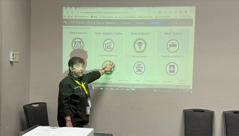
The CLSS has been in development since 2022 and has since focused on grassroot engagement with emergency management agencies of all staffing levels and community sizes. Several agencies have piloted the tool and feedback gathered has positively influenced its design, features, and workflows.

Additionally, agencies have reported that their evaluation of the CLSS in a pilot test or workshop has prepared them for deployment and even launched internal efforts to update current processes and policies for the lifeline construct and CLSS adoption.

Image
Carol Lynn, emergency manager from Humboldt County, Nevada, displays CLSS during an exercise conducted during the county’s pilot test.
Carol Lynn, emergency manager from Humboldt County, Nevada, displays CLSS during an exercise conducted during the county’s pilot test. “As a small county emergency management program, we were able to see the value that CLSS brings to operationalizing lifelines. Community Lifelines are the future, and we will be joining that future,” said Lynn. Photo credit: G&H.

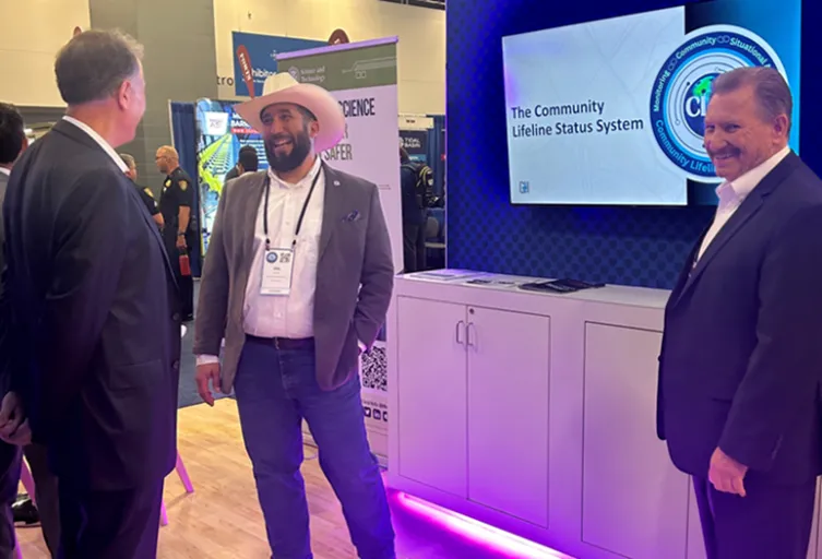
To date, 152 agencies representing 40 states and all 10 FEMA regions have participated in CLSS workshops, pilot tests, and webinars. Evaluation of the CLSS during real-world events and exercises with responders has provided several opportunities to validate the tool’s capabilities and value. Hundreds of professionals have also been briefed at emergency management conferences as well, including the 2024 National Homeland Security Conference in Miami, where the team’s presentation, Operationalizing Community Lifelines Through Data: A Miami-Dade Use Case of CLSS, was voted Best of Show.

Image
CLSS leads Hal Grieb and Michael Dossett demonstrate CLSS for Under Secretary for Science and Technology Dr. Dimitri Kusnezov at the 2024 National Homeland Security Conference.
CLSS leads Hal Grieb and Michael Dossett demonstrate CLSS for Under Secretary for Science and Technology Dr. Dimitri Kusnezov at the 2024 National Homeland Security Conference. Photo credit: G&H.

In late August, the team deployed the CLSS for the first time to agencies in Maryland and Virginia, a deployment that will ultimately culminate in a multi-state exercise evaluation in Spring 2025. Ron Langhelm, S&T Community and Infrastructure Resilience lead and CLSS Project Manager, welcomed emergency managers, stating: “…We’ve been talking for a good 4-5 years about modernizing the Community Lifeline Status System and the construct of how we get to a point where we can help do that with a data-driven approach…This is a big step in getting there and I appreciate your participation.” Upon successful deployment, evaluation and testing will expand to additional agencies across multiple states, counties, and cities nationwide in early 2025.

CLSS FAQs, deployment requirements, technical updates, newsletters, webinars, and more are available on the CLSS website. Complete deployment details will be showcased at the 2025 National Hurricane Conference in New Orleans. 

For more information about the platform, view S&T’s CLSS fact sheet. Contact STMedia@hq.dhs.gov for questions about upcoming assessments and demonstrations.

Last Updated: 09/12/2024
Was this page helpful?
This page was not helpful because the content