


September marks the start of several important American traditions—kids are back in school, football games are on tv, and pumpkin spice is on the menu. It’s also National Preparedness Month, when we take steps to ensure we have the resources needed to protect ourselves, our families, and our communities in an emergency.
S&T is working year-round to make sure emergency managers and first responders have the tools and technologies needed to protect their communities. As we’ve seen in recent years, there are an increasing number of extreme weather events such as wildfires, hurricanes, and heat waves that threaten the nation. Staying ahead of these threats requires new capabilities that take advantage of technical and scientific innovations to help public safety officials predict and mitigate the effects of extreme weather.
Knowing what’s coming
The Emergency Preparedness and Response to Weather Extremes initiative (EMPOWER) pilot program, a collaboration between S&T and the State University of New York (UAlbany), is actively developing a package of weather-related support tools that give federal, state, and local first responders access to real time analytics/artificial intelligence, weather data, and visualization capabilities. Weather stations are equipped with automated environmental and weather sensors, collecting critical data such as temperature, humidity, wind speed and direction, air pressure, precipitation, solar radiation, snow depth, and soil information, and utilize high-definition cameras that capture photos of the surrounding environments every five minutes.
This data is then shared with regional emergency personnel to help them respond as severe weather events occur. Getting that insight in real time is critical to coordinating an effective response and any potential evacuation efforts.
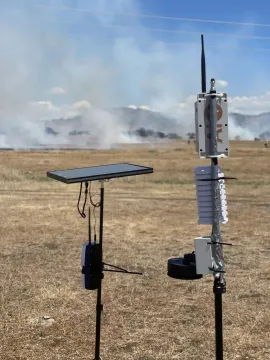
S&T’s wildland fire sensors are currently being piloted across the U.S., including in communities in Hawai’i, California, Oregon, and Colorado. These sensors alert agencies to early ignitions, allowing responders to get to the source and suppress the blaze before it spreads out of control. Advanced notice of an imminent fire hazard could also grant time needed for communities to make life-saving evacuation decisions. As we saw in last year’s tragic Lahaina wildfires, these emergencies can escalate rapidly and devastate communities, so having more time to coordinate response is essential.
The Coastal Resilience Center (CRC), a Center of Excellence funded by S&T, is working to arm communities with modeling and evaluation tools that will give local leaders a leg up in boosting response and resiliency. Last year during hurricane season, CRC—led by the University of North Carolina at Chapel Hill in partnership with Jackson State University, a Historically Black College and University—used its high-performance ADvanced CIRCulation model (ADCIRC) to forecast storm surges, tides, and coastal circulation.
During Hurricane Ian and Hurricane Idalia last August, ADCIRC provided detailed prediction of storm category, landfall location, radius, wind speed, surge levels, and storm track. This information was incorporated into daily operations briefings for DHS leadership and informed local communities across the East Coast, helping emergency managers manage resource deployments and track progress of response efforts.
Having the tools they need
S&T’s Wildland Firefighter Respirator is small, lightweight, and easy to wear, and is designed to protect wildland firefighters from fire-borne particulates and toxic gases they may encounter in the field. S&T has worked with the California Department of Forestry and Fire Protection, International Association of Fire Chiefs, U.S. Forest Service, and fire departments around the country to develop, test, and evaluate the technology, which is now undergoing NIOSH and NFPA certifications. This tech provides an important improvement in personal protection for wildland firefighters, who can’t be weighed down with bulky breathing equipment as they work across miles of remote areas.
Episode 4 of this season of the Technologically Speaking podcast features Ron Langhelm, program manager for S&T’s Community and Infrastructure Resilience Program (C&IR) who discusses the work he does helping communities to be better prepared for disasters like floods, earthquakes, wildfires, and hurricanes by connecting them with the tools that they need to get back up and running. C&IR also assists with infrastructure resilience, assisting communities to identify in advance what they need to mitigate disaster-based impacts.
The H2Rescue is a hydrogen fuel cell/battery hybrid vehicle that can be driven to disaster sites to provide 25kW of export power to support emergency response operations for up to 72 hours without refueling. S&T, the U.S. Department of Energy (DOE), the Department of Defense, and Cummins, Inc., developed the prototype. With the increasing frequency of natural disasters, it is critical that we develop and leverage new and emerging green technologies that can be employed during disaster relief efforts and do not require fossil fuels for operation.
The digital indoor map navigator Mappedin was completed in 2022 and has since flourished. Navigating complex mazes of hallways and corridors in potentially chaotic or low-visibility situations can be tricky, and hard copy or digital building blueprints can be cumbersome or even outdated, adding precious seconds when time is of the essence. Developed by S&T and digital indoor map navigator Mappedin, the online Mappedin mapmaking subscription converts floor plans into interactive and easily maintainable digitized maps. With easy-to-use mapping tools and data, Mappedin provides high-quality 3D map creation, data maintenance, and map sharing for advance preparation and planning, and assistance during emergency incidents. First responders arriving on the scene can use Mappedin to visualize the interior layout of structures before entering a building and make life-saving decisions.
These are just a few of the efforts currently underway at the Directorate, and I encourage you to explore more of our preparedness-related work. Helping communities to have the tools they need, before they need them, is an important way that S&T carries out its mission to protect our nation. Seasons change, but staying prepared is important all year long.