

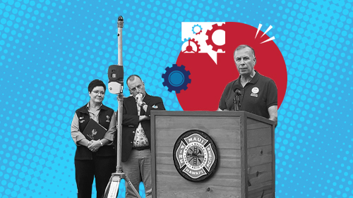
When first responders and emergency managers want to ensure they’re prepared to handle any crisis, they turn to the Science and Technology Directorate (S&T). S&T is the trusted technical expert and central research and development (R&D) hub for the Department of Homeland Security, the nation’s public safety officials, and those who serve at the local, state, territorial, and tribal levels.
S&T invests in force-multiplying solutions that give decision makers the right tools and information they need to do their jobs safely and effectively. From conducting real-world technology evaluations to developing new alert systems and investigative capabilities, S&T operationalizes technology to strengthen community preparedness.
The following projects are a sampling of current S&T efforts supporting public safety and DHS Components. For a comprehensive list of available resources, please see the new trio of first responder resource guides.
Data Processing and Analytics
Procuring the newest technology is just the first step in preparing for the future, but having the latest gadget doesn’t guarantee success. Responders need to trust that their equipment is going to work as intended in an emergency. S&T’s testing and evaluation efforts give public safety officials confidence that their gear and tools are up to the job.
- Image
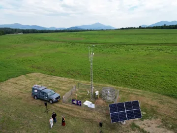
Environmental and weather sensors collect critical data that enable emergency personnel to prepare for and respond to severe weather events in real time. Photo credit: UAlbany. Advanced Opioid Trafficking Analytics to Aid Investigations – software that can be integrated with Homeland Security Investigations’ Repository for Analytics in a Virtualized Environment (RAVEN) platform to better recognize data patterns and enhance investigator effectiveness.
- Emergency Preparedness and Response to Weather Extremes (EMPOWER) – pilot program in collaboration with State University of New York (UAlbany) developing a suite of weather-related support tools that can give first responders access to real time analytics/artificial intelligence (AI), weather data, and visualization capabilities.
- Homeland Explosive Consequence and Threat (HExCAT) – rapidly analyzes the human health consequences from an explosion, the current medical ability to respond, and various mitigation and response strategies emergency planners can use.
- National Emergency Response Information System (NERIS) – collaboration with the Federal Emergency Management Agency and U.S. Fire Administration to develop a secure, cloud-based interoperable fire information and analytics platform.
- WIFIRE Edge – collaboration that developed and tested a new data processing and modeling system that uses edge computing and AI to analyze data from sensors attached to firefighters and their equipment.
Early Alerts and Warnings
Advances in sensors and data processing capabilities have made early warning systems more useful in emergency management, providing more reliable analysis of emerging incidents and reducing the number of false alarms. S&T is investing in technologies such as AI and digital analytics that can rapidly process complex datasets to alert officials and civilians at the outset of an emergency.
- Image
FloodAdapt enables users to see how floods could impact their community and model how various demographic factors may affect recovery. Photo credit: Deltares USA. FloodAdapt – suite of flood-hazard modeling and impact assessment technologies that can help inform field operations and emergency response before and after flood events make landfall.
- Internet of Things Low-Cost Flood Inundation Sensors – rapidly measure rising water levels and report flood conditions, providing early warning to communities that could greatly reduce potential casualties and damage.
- Next Generation Flood and Wildfire Alerting Technology – provides life-saving critical emergency alerts to people in affected areas on their mobile devices and vehicle infotainment systems so they can take appropriate action.
- Wildland Fire Sensors – advanced sensors that can locate and help firefighters suppress an ignition before it spreads, as well as grant time needed for communities to make evacuation decisions.
- Wildland Urban Interface Emergency Alerting – technology that integrates unattended flood and wildfire sensors with IPAWS Open Platform for Emergency Networks to provide critical emergency alerts in affected areas on mobile devices and vehicle infotainment systems.
Information Sharing
Having the right information is critical when coordinating an emergency response. S&T is developing new systems that both aggregate and analyze data across platforms and jurisdictions to help emergency managers and responders on the scene make time-sensitive, informed decisions.
- Community Lifeline Status System (CLSS) – reporting construct that will provide the emergency management community with a comprehensive systematic approach to lifeline status planning, monitoring, and reporting across areas impacted by a disaster.
- Emergency Management of Tomorrow (EMOTR) – dedicated research agenda that supports emergency managers with effective information sharing technologies and a single resource for breakthrough research.
- Fentanyl Reference Spectra – provides vendors of field-portable detection equipment with expanded library of restricted chemicals to help improve instrument capabilities in detecting dangerous substances such as fentanyl.
- Maritime Safety and Security Roadmap – 10-year capability roadmap outlining current and future demands across DHS to help inform future initiatives and budget requests.
- Search and Rescue Common Operating Platform (SARCOP) – interagency dashboard that aggregates multiple mobile and web-based applications and analytics systems to map out where search and rescue operations have occurred.

Public Event Security
Preparing for the worst is often the best way to prevent disasters, particularly man-made ones. S&T is developing tools and resources for emergency managers and first responders that can help them prepare for large public events to protect life and property from ever-evolving threats.
- Image
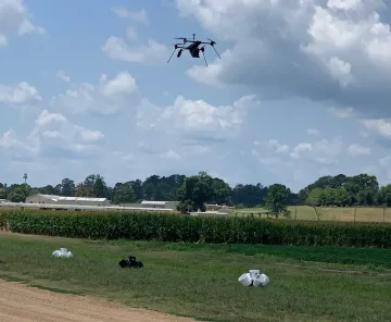
The Bellbird Aerial Communications Platform hovers over a series of bucket targets during a July 2024 operational field assessment (OFA) in Mississippi. Photo credit: S&T. Bellbird Aerial Communications Platform – unmanned aerial system equipped with a powerful speaker and microphone that allows for clearer two-way communications with large groups of people at the same time.
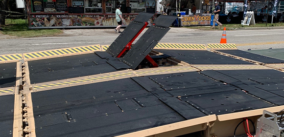
- Deployable Expedient Traffic Entry Regulator (DETER) – versatile vehicle barrier that provides fast protection in multiple scenarios.
- Predictive modeling tool – developed by the Chemical Security and Analysis Center, used to help secure both indoor and outdoor events during the week leading up to Super Bowl LVII.
- Ready Armor Protection for Instant Deployment (RAPID) – quickly deployable barrier for critical asset protection and urban operations that can be set up with just a few people.
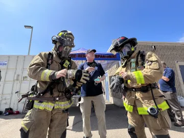
Responder Safety
The people serving on the front lines of homeland security and public safety put their lives on the line for their communities. S&T is committed to developing new solutions that keep them safe on the job, whether through improved personal protective equipment or unit management technologies.
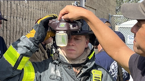
- C-THRU Real-Time Indoor Visualization System –helmet-mounted indoor visualization system that helps firefighters navigate in low visibility settings and shares critical information with command.
- Image
Firefighters don their gear at the C-THRU Navigator operational field assessment. Photo credit: S&T. MappedIn – 3D map creation and sharing tool that allows city executives, building owner operators, and first responders to transform indoor floorplans into interactive digitized maps.
- Non-detonable training aids for explosives detection canines – market survey report that provides information on 12 non-detonable training aid products that allow detection canines and their handlers to train safely for real-world scenarios.
- Wearable chemical sensor badge – portable chemical sensor that detects toxic industrial chemicals first responders are often exposed to when they arrive on the scene of an emergency.
- Wildland Firefighter Respirator – small, lightweight, easy to don and doff breathing apparatus that will remove airborne hazards from the air without weighing down the wearer.
Keeping pace with rapid technology changes and anticipating their impact on the future is a full-time job, and it’s a role S&T is proud to serve in support of the people working on the front lines to protect the nation. When questions arise about what new emergency management tools are available or what standards are essential for responder equipment, trust S&T to provide objective, relevant guidance.
Stay up to date on the latest innovations and breakthroughs—bookmark the Community and Infrastructure Resilience and First Responder Capability webpages for more updates on public safety resources, and subscribe to the Technologically Speaking podcast.